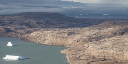
The river deltas along the coasts of Greenland are growing heavily as a result of the melting ice, and this may create problems for the ship traffic in several locations. The latest research from DTU joins the large number of scientific articles documenting a Greenland that is changing rapidly.
Studies of 121 Greenland river deltas show that the deltas have grown heavily over the past 75 years. The river deltas have not only grown in size, they have also prograded so that they extend further out into the fjord or sea into which the river flows. In other words, it is today easier to cross a Greenland river delta dry-shod because it has become a larger area with land.
“The progradation of the river deltas is a derived effect of the melting of the Greenland Ice Sheet,” explains Associate Professor Shfaqat Abbas Khan from DTU Space, who has contributed to the understanding of these changes through research collaboration headed by University of Copenhagen (UCPH). The research was published in Nature in October 2017.
"The river deltas are growing in size because the melt water carries more sediments with it, which are deposited in the estuary of the river. Concurrently, the Greenland bedrock is rising by an average of two-three centimetres a year as a result of melting ice. There is quite simply less mass pressing down the bedrock. When the bedrock rises, more land emerges from the sea, resulting in increased sediment deposition and thus the growth of the deltas,” says Shfaqat Abbas Khan.
For Greenland, climate change has had the reverse effect in some places in relation to rising water levels, namely that more land is emerging from the sea because the bedrock is rising.
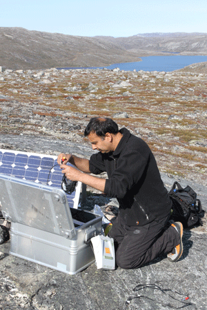
60 GPS stations monitor the bedrock
DTU Space has more than 60 GPS stations spread out across the Greenland bedrock, and they have delivered data which Associate Professor Shfaqat Abbas Khan has processed. Using modelling and analysis, it is possible to calculate how much the bedrock rises. When DTU Space began measuring the changes over 20 years ago, it was ascertained that the bedrock was rising by around 2 cm a year. Today, the bedrock rises 3 cm a year in the areas that are closest to large glaciers. This shows that the ice is melting at an accelerating pace and that the bedrock is rising more rapidly.
The extent surprises Shfaqat Abbas Khan.
“A GPS station measures changes with pinpoint precision, and not just in the immediate vicinity. It is sensitive in a radius of up to 100 kilometres. A huge volume of mass must be removed before the bedrock reacts, meaning that massive areas must melt before the GPS station reacts,” explains Shfaqat Abbas Khan.
Unique aerial photographs from World War II have made it possible for the team of researchers from UCPH to study changes of the Greenland river deltas dating back as much as 75 years. Through a comparison with aerial photographs from recent decades, the researchers can ascertain that there were no changes to the river deltas from 1940 to 1980. But from 1980 and onwards, they begin to change. And at an increasingly rapid rate.

Larger river deltas may cause problems for ships
This is the complete opposite of the development of river deltas in the rest of the world, where they are almost disappearing due to flooding from the rising sea. With the new studies of the Greenland river deltas, it can also be ascertained that the Greenland coasts are developing differently to other arctic coasts.
“Large areas are being eroded along the arctic coasts, while we are seeing the opposite development in Greenland. Our research shows that climate change in the arctic regions is affecting coasts differently,” says Postdoc Mette Bendixen from Center for Permafrost (CENPERM) at UCPH.
The growing river deltas and the rising bedrock are not just matters of curiosity among scientists, but may cause problems, partly for Greenland fishermen, and partly for the ships that bring goods and tourists to the villages in Greenland,” says Shfaqat Abbas Khan.
“The seaward approach may be blocked by sediments and rising bedrock, and new skerries may also appear, which will complicate—and perhaps even threaten—navigation in Greenland waters,” he says.
Greenland is changing rapidly
For many years, the Associate Professor has followed climate change in Greenland through his research. In 2015, he thus also co-authored a fundamental Nature article in collaboration with University of Copenhagen documenting that the Greenland Ice Sheet is melting at an accelerating rate and that the situation is much more dramatic now than at any other point in time in the past 115 years.
Shfaqat Abbas Khan has developed a method for calculation of ice mass loss based on observations of the so-called trimlines, which are marked lines in the Greenland mountains that indicate the extent of the ice over time. The research contributed to making it possible to estimate for the first time that the melting of the Greenland Ice Sheet has contributed with 2.5 cm to the global sea level during the 20th Century.
When summing up his knowledge about Greenland based on his research findings, Shfaqat Abbas Khan says:
“We’re seeing some huge changes in Greenland in these years. And I think that we’ve only seen the beginning. There will probably be even bigger changes in Greenland due to climate change because it’s all accelerating. For Greenland, this entails some challenges, for example in relation to infrastructure. How do you plan your infrastructure—for example a new port—if you cannot sail to it in twenty years? There’s no doubt that Greenland is facing greater challenges than the rest of us in relation to long-term infrastructure planning.”
During World War II, the US Air Force made a large number of flights over Greenland to locate German weather stations. In this connection, thousands of aerial photographs were taken.
They were subsequently handed over to the Danish Energy Agency and are today kept in a basement in Copenhagen. By comparing the old aerial photographs with Google Earth images of Greenland, it has been possible for the researchers to document the changes of the Greenland river deltas.
The research findings were published in Nature in October 2017 with the title ’Delta progradation in Greenland driven by increasing glacial mass loss’