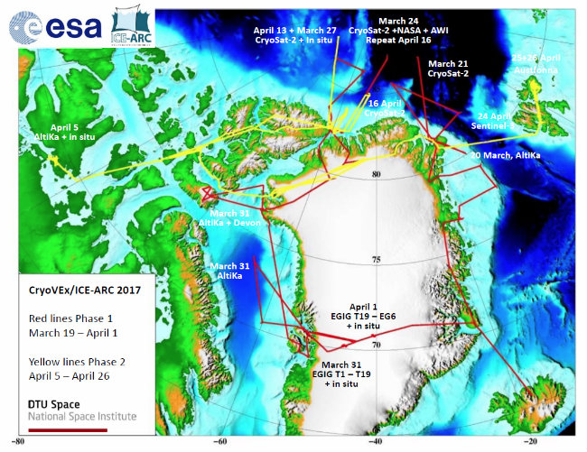
In spring 2017, an international team led by DTU Space has mapped the ice above the sea and land from Canada over Greenland to Svalbard to gain as detailed a picture as possible of climate change in the region—and at the same time gain a better understanding of precisely what the new satellites are measuring over the sea ice and ice caps.
Together with international partners, a team of researchers and experts from DTU Space has now completed a comprehensive aerial survey campaign in the Arctic. During spring, the team has been busy mapping the ice over land and at sea in the northern part of the Arctic region, conducting extensive measurements from small, twin-engine aircraft. The project has also put researchers down on the ice—both on the ice caps and on the sea ice in the Polar Sea north of Greenland and Canada.
In addition to mapping climate change in the region, the campaign’s measurements are used to improve the understanding of what newer radar satellites as CryoSat, AltiKa, and Sentinel 3 are in fact measuring over the sea ice and the ice caps, thus ensuring that measurements will be even more precise in future.
The project is an ESA cooperation headed by DTU Space. Together with ESA’s and NASA’s satellite surveillance, the measurements form part of the total overview of the state of the Arctic ice sheet, and are therefore an important parameter in the work of monitoring the rapid climate change currently taking place in the region due to global warming.
Retreating ice
In recent years, the region has experienced warmer temperatures and thus dwindling ice, exacerbating global warming as there is less ice to reflect heat from the sun back into space. Instead, this heat is stored—in the Arctic Ocean, among other places.
The measurements were taken at regular intervals over several years, and the results this year do not seem indicate a deviation from the trend.
“While we still face the major task of analysing the results, we can already see significant changes, especially in the ice conditions north of Greenland,” says Professor René Forsberg from DTU Space.
The work was performed under difficult arctic conditions that require excellent logistics. The mission extends over a couple of thousand kilometres from Cambridge Bay in Arctic Canada in the west—over Greenland and Svalbard in the east.
“Getting people on the sea ice presents a unique logistical challenge, and this has only been possible through cooperation with Canadian researchers and the use of the Alert military base on Ellesmere Island,” says René Forsberg.
A Danish-British field team has taken measurements on the ice on top of Greenland’s ice cap in temperatures of down to minus 45°C.
More precise measurements
Aerial measurements were performed using laser scanning and radar—further supplemented by data from the surface of the ice.
These measurements are compared against the radar measurements from satellites used for climate monitoring. Among other things, this is done by flying along the same satellite ‘tracks’. Satellite measurements over large areas are then checked against the more precise aircraft measurements over smaller areas far closer to the surface—and via points on the ice.
The different measurements enable researchers to form a picture of the height and dissemination of the ice with pinpoint precision when the many data are subsequently processed and analysed. The current campaign is using data from—among others—ESA’s CryoSat satellite, the French-Indian SARAL/AltiKa Altimetry Mission, and the Sentinel-3 satellite from the EU’s Copernicus constellation.
One of the places being measured is the Austfonna ice cap, which extends out into the sea from the Nordaustlandet island off Svalbard. “We can see that the Austfonna ice cap is losing more ice every year. This is almost certainly a consequence of global warming. If the trend continues unabated, the result will more or less be a phasing out of this ice cap,” explains DTU Space Researcher Sebastian Bjerregaard Simonsen, who recently returned home from the region.
DTU Space participates in a number of recurring annual measurements of both the ice caps and the sea ice in the Arctic region, thus monitoring the topography and spread of the ice over an extended period and gaining new knowledge about the impact of climate change in the region.
In 2017, measurements were taken over a six-week period involving almost 150 flying hours. A total of six aircraft took part in the campaign—two DTU chartered planes—two from NASA—and two from Canada. Five experts and researchers from DTU participated in this year’s measurement survey.
In addition to measuring the ice itself, the mission is also tasked with obtaining new knowledge about surveying techniques, testing new instruments, and validating data from satellites monitoring the same areas.
The surveying work was, among other things, performed in cooperation with NASA, which maintains Operation Ice Bridge—and the European Space Agency, which funds a large part of the work of validating data on ice on sea and land—among other things to understand data from current satellites such as CryoSat, launched in 2010, and as a basis for the design of future satellite missions. The project is also supported by the EU through the project ICE-ARC (Ice, Climate and Economics), whose aim is to generate knowledge about the effects of climate change on the ice and its importance for society.
In addition to DTU Space—which was responsible for overall project coordination—ESA, NASA, and researchers and logistics experts from institutions in Canada, Norway, the USA, the Netherlands, and the UK participated in the project.

Map of aerial measurements performed in the Arctic in the spring of 2017 from Canada in the west to Svalbard in the east. (Kort: DTU Space/ESAS)